


New Delhi: Goodbye FASTAG, Hello Global Navigation Satellite System! The introduction of FASTag marked a significant advancement in India’s toll collection system, enhancing efficiency and reducing congestion across the country’s highways.
However, this system might soon be succeeded by an even more sophisticated technology: the Global Navigation Satellite System (GNSS), which promises to address the current system’s remaining inefficiencies.
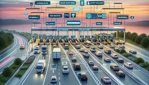
Understanding FASTag and Its Limitations
FASTag, a pioneering solution based on Radio Frequency Identification (RFID), has revolutionized toll collection by automating toll payments as vehicles pass through toll booths.
This system has notably minimized cash transactions and reduced long queues at toll plazas. Despite its success, FASTag is not without flaws.
Issues such as overcharging, toll evasion, and ongoing congestion at certain toll points have prompted the search for a more advanced solution.
Introducing GNSS
So, what exactly is GNSS? The Global Navigation Satellite System represents the next step in toll collection technology.
Unlike FASTag, which relies on fixed toll locations and vehicle classifications, GNSS uses real-time satellite tracking to determine toll charges based on the exact distance traveled.
By monitoring a vehicle’s journey from entry to exit on a highway via satellites, GNSS ensures that drivers are charged based solely on the distance they cover.
This shift from a fixed fee system to a distance-based one is set to transform how tolls are calculated and collected, offering a fairer pricing model.
Benefits of GNSS
GNSS promises several advantages for both drivers and the government. For motorists, the key benefit is a streamlined tolling experience.
By removing traditional toll booths, GNSS aims to eliminate traffic bottlenecks and queues, and with distance-based charges, drivers will avoid overpayment for shorter trips.
For the government, GNSS enhances security and efficiency in toll collection, reducing toll evasion and providing valuable data for traffic management and infrastructure planning.
Phased Implementation of GNSS
The transition to GNSS will be gradual. The Indian government plans to introduce the system in phases, starting with a hybrid model that integrates GNSS with existing FASTag technology.
Initially, only a few lanes at selected toll plazas will feature GNSS, allowing for a smooth adaptation to the new system.
As the technology evolves and its benefits become evident, GNSS will eventually replace all traditional toll booths.
Testing for GNSS has already commenced on two major highways: the Bengaluru-Mysore National Highway (NH-275) in Karnataka and the Panipat-Hisar National Highway (NH-709) in Haryana.
How GNSS-Based Toll Collection Functions
GNSS operates through a combination of satellite technology and onboard units installed in vehicles. As a vehicle enters a toll road, satellites track its journey.
Upon exiting, the system calculates the distance traveled and automatically deducts the corresponding toll from a digital wallet linked to the vehicle’s registration.
This eliminates the need for manual transactions and has proven effective in several European countries.
Economic Impact and Future Vision
The introduction of GNSS is expected to significantly impact the economy. Currently, the National Highway Authority of India (NHAI) collects around ₹40,000 crore annually from tolls.
With GNSS, this figure could potentially rise to ₹1.40 trillion in the next two to three years, providing a crucial boost for infrastructure development and maintenance.
Union Minister Nitin Gadkari has expressed his vision of enhancing India’s road network to match international standards by the end of 2024.
He believes that GNSS, alongside projects like Bharatmala-2, will be instrumental in achieving this ambitious goal.